
Vancouver is the ever-growing coastal seaport city located on the South-West corner of mainland British Columbia. The original settlement established in 1867, named Gastown grew around the Hastings Mill. It eventually grew to become the townsite of Granville before being renamed Vancouver as it was incorporated as a city in 1886. As the city grew, smaller communities started becoming more evident and Vancouver became a city of neighborhoods. There are now 21 distinguished neighborhoods in Vancouver, and although the actual borders between them are inexact, they each have their own unique character.
Separated into sections of Central Vancouver, West Side, East Side and South Vancouver a brief overview of the neighbourhoods will be give. As previously mentioned the actual borders are inexact and are occasionally merged into sub-neighbourhoods or into more than one of the 4 directional quadrants.
Central Vancouver:
Downtown
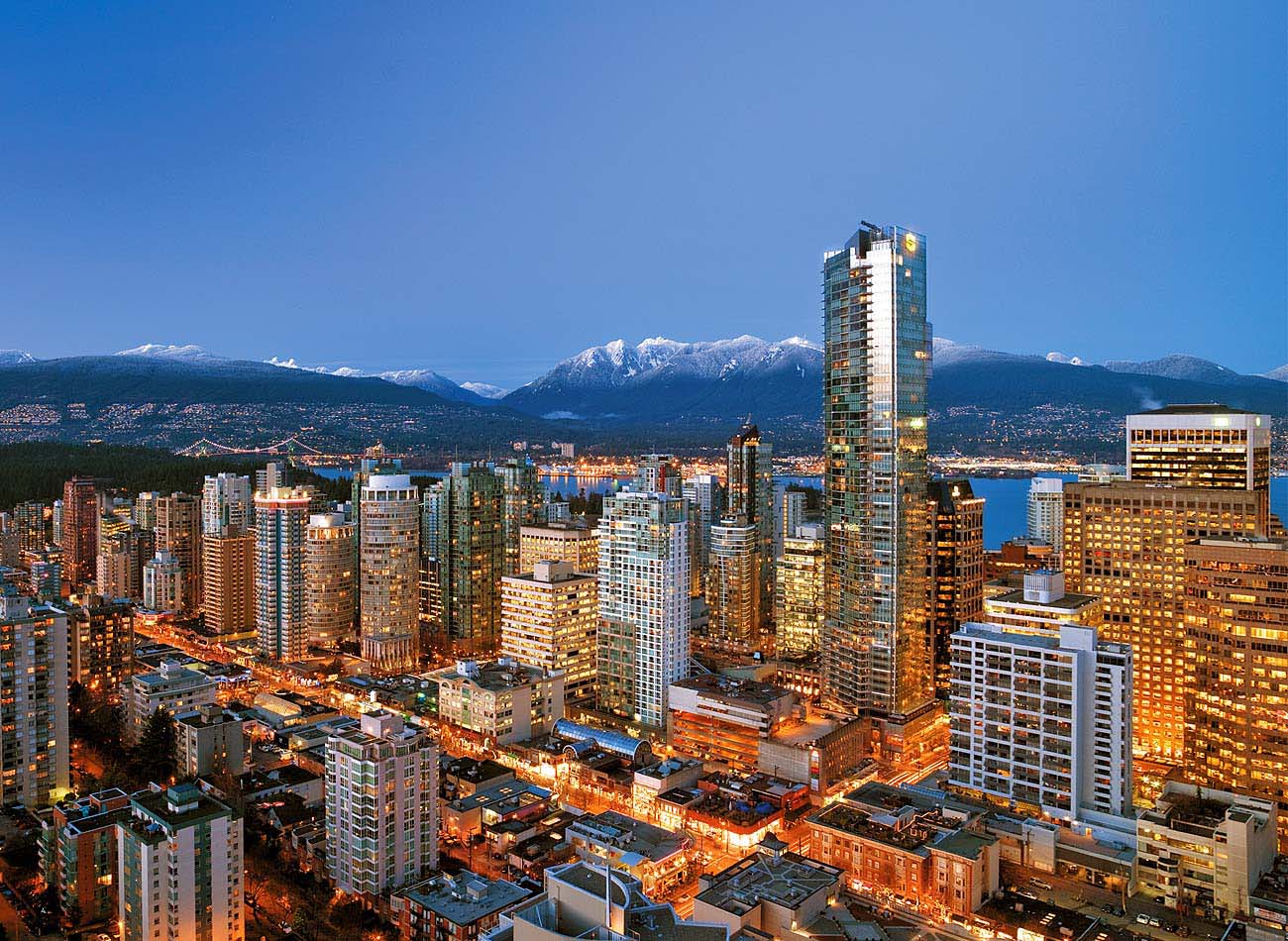 |
| View of Vancouver's tallest tower the Shangri-la in Downtown Vancouver |
This is the main business district, within here we see many of the major business' office towers. Also a key area for the city's main entertainment venues, such as Rogers Arena, BC Place Stadium, and many theaters and clubs. Many of the high rises also include residential spaces, creating a very dense city. This mixture of residential and commercial urban planning technique has since been dubbed Vancouverism.
West End
 |
| View across English Bay towards the West End |
This very lively region is a mixture of small commercial and residential spaces. The residents of the region have long fought to keep the region very livable, having kept traffic in the area low, eliminated prostitution that was prevalent in the early days, and maintained a welcoming community atmosphere. This region is also home to Vancouver's gay community, as the Davie Village houses a substantial amount of Vancouver's gay population. On the Western shores is English Bay Beach which is filled each year for the annual "Celebration of Light" fireworks display.
Yaletown
 |
| Yaletown from False Creek |
Yaletown is one of the heritage areas of the city. Originally Vancouver's home to warehouses, the area has since been revitalized, due to Expo 86, to transform the building uses into new commercial and residential spaces. These wonderful new towers overlook False Creek on the South end of the downtown core creating one of the most densely populated areas in Vancouver. Due to its location, much of the architecture was forced to fit within the city guidelines regarding View Corridors; as shown in the picture, the towers rise from the further it gets from the "view origin".
Coal Harbour

Coal Harbour is the city's former port area. Similarly to Yaletown this area faced major redevelopment, transforming the spaces into a residential area, with some commercial space. Located between Downtown Vancouver and Brockton Peninsula in Stanley Park, the region was named after coal was found in the harbour in 1862.
Gastown
 |
| Statue of "Gassy" Jack of which Gastown received it's name |
With streets that are still cobblestone, Gastown is the heart of Vancouver heritage. With a few residential spaces, this area is mostly filled with tourist shops, boutiques, restaurants and clubs. It is also the home of the famous Gastown Steam Clock which is a must-see landmark for many tourists. In 2009 Gastown was designated a National Historic Site of Canada.
Chinatown

Where many of the Chinese immigrants established themselves upon arriving in Vancouver, this region is known for being Canada's largest Chinatown. While once prosporous, the region has been in decline as many residents moved into other areas of Vancouver. Many revitization efforts are in motion as the region still remains an attraction for tourists but lacks the lustre it once had. One landmark within this region is the Dr. Sun Yat-Sen Chinese Garden as it promotes the preservation of Chinese culture in the city. In 2011 this area was also designated as a Nation Historic Site of Canada.
Downtown Eastside
| View of Downtown Eastside from the Harbour Centre |
This area is well known across the country as being one of the poorest. Home to many of the city's drug addicts and homeless, the area has become rundown. Despite the downward trend, the people within the area are resilient, often coming together to help one another and make the best of a bad situation. The area is also home to some local artists, including the East Side Monument
West Side:
Arbutus Ridge
This residential area can be best described by its large lot sizes with stately homes and tree lined streets. Many of these restored heritage homes have excellent views of the North Shore mountains.
Dunbar-Southlands
Archaeological findings have shown that people have resided in the Southlands for centuries, with some predictions that Indians established themselves as early as 400 BC. Today the region is mainly single family residences with small commercial spaces. Known for its gardens and tree lines, the cherry trees come to blossom each spring adding vibrancy and colour to the neighborhood
False Creek
Sitting opposite of Yaletown on the south side of False Creek, this region is in another transformation stage as it begins to develop more residential spaces. Originally an industrial park, this area has been used in various ways before coming to its current direction. This region is also home to Vancouver's Olympic Village, built for the 2010 Winter Olympic Games.
Granville Island/Fairview
 |
| Entrance to Granville Island under the bridge |
One of Vancouver's largest attractions, Granville Island is a vibrant peninsula located under the south end of the Granville Street Bridge. Once an industrial manufacturing area, the area has changed to a hot spot of entertainment. The area has a public market, the art university Emily Carr, Granville Island Brewery and many other fun activities and restaurants. Due to the ease of access to the downtown core, the rest of the region quickly developed with residential and commercial spaces.
South Cambie-Oakridge
This region is home to residential neighborhoods, shopping mall, and the Langara Golf Course. The region also has a large Jewish community presence.
Kerrisdale

Despite being known as a small shopping district, the region is mostly residential. A mixture of various housing is prevalent throughout the area. Many shoppers will find themselves meeting at Kerrisdale Village to find unique handcrafted furniture and other items.
Kitsilano
 |
| Kits Beach with downtown located in behind |
Located along the South shore of English Bay, "Kits" (as it is referred) is home to the extremely popular Kits Beach. Named one of the "10 best city beaches in the world", Kits Beach offers an excellent view of downtown Vancouver and presents visitors with plenty of activities and spots to enjoy themselves. The neighborhood also is home to some of Vancouver's more famous residents, such as renown environmentalist David Suzuki, Lululemon founder Chip Wilson, and various others.
Marpole
This residential area located north east of Vancouver International Airport is continuing to develop to attract people to the region. A plan is currently in place to increase tourism to the West Vancouver neighborhoods, centering around Marpole.
Shaughnessy
 |
| VanDusen Visitor Centre |
Home of Vancouver's richest, this neighborhood is filled with the city's largest and most expensive properties. Some of Vancouver's most prestigious private high schools are located in the area. This region is also home to the extremely beautiful VanDusen Botanical Gardens.
Point Grey
 |
| View of Vancouver from Jericho Beach |
One of Vancouver's older neighborhoods, with plenty of longtime residents, the area is best know for its beaches Jericho and Spanish Banks. The excellent view of the sunset makes it a very attractive location for summertime visitors. The neighborhood is a mixture of some of Vancouver's most exclusive residences and college students that study at the nearby University of British Columbia.
East Side
Commercial Drive-Grandview
This area is a very multicultural region of Vancouver, with a large number of local ethnic stores and community groups. The area also boast plenty of European-style cafes, bars and shops and entertainment venues. As of 2007 there were 93 restaurants on Commercial Drive alone, of which 19 are coffee bars. Long has the region been the destination for immigrants, the residents has significant presence of Italian, Asian, Latin American, East Indian and African communities.
Hastings
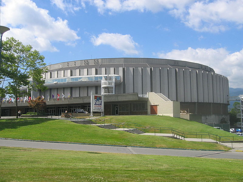 |
| The Pacific Coliseum at the PNE |
Primarily a residential area, the Hastings neighbourhood is also home to the Pacific National Exhibition (known as PNE) and Hastings Park racetrack. Within the PNE, which has been around since 1910, is Playland, Vancouver's premier amusement park. Also on PNE grounds is the Pacific Coliseum which was home for the National Hockey League's Vancouver Canucks for a number of years and is the current home to the WHL's Vancouver Giants hockey club.
Kensington
Another multicultural enclave of Vancouver, this area has the city's only lake, Trout Lake. There is also a thriving colony of artists, many working in residential live/work studios.
Killarney
Just North of the Fraser River, this area borders nearby Burnaby. One of the last areas of Vancouver to be developed, it contains a number of green spaces and single family residences with a few multi-family residences as well.
Mount Pleasant
Located close to False Creek, this area had previously contained a few warehouses. It has since been known as a vibrant area known for its unusual stores, heritage buildings, artistic residents and arts-focused festivals.
Main Street-Riley Park
 |
| Historic Nat Bailey Stadium |
Riley Park is home to the Vancouver Olympic/Paralympic Centre and to Nat Bailey Stadium, home of the Vancouver Canadians baseball team. The area has two thriving hubs of unique boutiques, grocers, and restaurants, one along Main Street and another along Cambie Street.
Renfrew-Collingwood
Primarily a residential area, this areas still maintains good access to nature. Still Creek runs through the area, providing residents with a nice place to go for a walk. On the Eastern border lies a few of Vancouver's film studio warehouses.
Strathcona
Located East of Chinatown, this area is currently in a revival state as many of the buildings have been designated heritage and are being restored. This prestige is attracting plenty of wealthy people to the area.
Sunset
This area is a working-class area filled with single family homes, low-rise apartments and small retail shops. Both Main Street and Fraser Street are vibrant shopping areas with plenty of independently owned stores and restaurants
Victoria-Fraserview
A great destination for fresh produce, sarees, fabrics, imported goods and international cuisine, this multiculturally diverse area is on Vancouver's south slope towards the Fraser River. Despite being one of the earliest developed areas of Vancouver, there are not many heritage buildings in the area.
South Vancouver
Dunbar, Kerrisdale, Marpole, Sunset-Victoria-Fraserview, and Renfrew-Kilarney
South Vancouver is also known to consist of these neighbourhoods, whose key features of the regions can be found above.

While an outsider may find it difficult to distinguish the difference between the neighbourhoods when exploring the city, they each have a meaningful tie to the city's history. Some began as immigration destinations, or ports and those shaped the regions that have become the neighbourhoods today. Each community is a bit different and offers people of all cultures a chance to find a mixture that suits them and their lifestyles. Vancouver is a wonderful inclusive city, being built of so many different neighbourhoods and character, that it certainly feels like home.
No comments:
Post a Comment